Europe
|
|
Gouter Route, Mont Blanc, France - 4808 m high
|
Tower Bridge, Ben Nevis, Scotland
- 1344m.
|
Mount Olympus, Greece – 2917 m high
|
Ararat, Turkey - 5165 m high
|
Via Ferrata di Marmolada, Dolomites, Italy.
|
Belukha also known as o Muztau, Russia - Mountain 4506 m
high
|
Vesuvius, Italy - 1281 m
high
|
Elbrus,
Russian – The western peak is 5642 m high, the eastern one is 5621 m high
|
Etna, Italy - 3340
m
|
Mulhacen, Spain - 3478 m
high
|
Asia
|
|
Imja Tse (Island Peak), Nepal
– 6.189 m high.
|
Lenin Peak, Kyrgyzstan - 7134 m high
|
Mera Peak, Nepal - 6476 m
high.
|
Mount Fuji, Japan - 3776 m high
|
Mount Khuiten, Mongolia – 4374 m
high.
|
|
América
|
|
Snake Dike, Half Dome, Yosemite, USA
– 1400 m
high.
|
Kain Route, Bugaboo Spire, Bugaboos, British
Columbia, Canada
- 3204 m high.
|
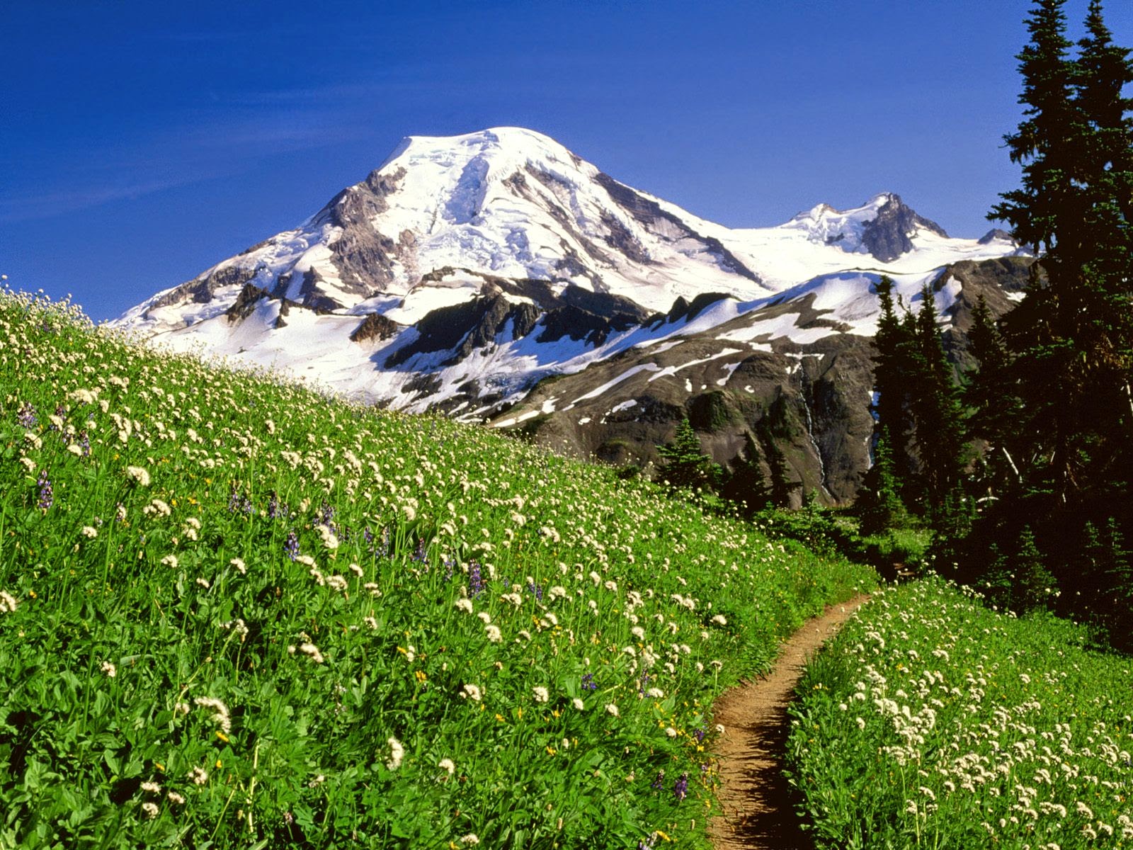
Mount Baker also known as Koma Kulshan or
simply Kulshan, Washington
County, USA
– 3286 m
high.
|
Aconcagua, Argentina – 6961 m high
|
Villarica volcano, Chile - 2860 m high.
|
Lanín
volcano, Argenita - 3776 m
high
|
Africa
|
|
Mount Sinai, Egypt - 2285 m
high
|
Kilimanjaro, Tanzania - 5895 m high.
|
Pacific
|
|
North-west ridge, Mt
Aspiring, New Zealand
- 3.033 m high.
|
|
Europe
|
Mulhacén, Spain – 3.478 meters
high.
Mulhacén is the highest mountain in continental Spain and in the Iberian
Peninsula. It is part of the Sierra Nevada
range in the Cordillera Penibética. It is named after Abu l-Hasan Ali, or Muley
Hacén as he is known in Spanish, the penultimate Muslim King of Granada in the 15th
century who, according to legend, was buried on the summit of the mountain.
Mulhacén is the highest peak in Europe outside the Caucasus Mountains
and the Alps. It is also the third most
topographically prominent peak in Western Europe, after Mont Blanc and Mount
Etna, and is ranked 64th in the world by prominence. The peak is not
exceptionally dramatic in terms of steepness or local relief. The south flank
of the mountain is gentle and presents no technical challenge, as is the case
for the long west ridge. The shorter, somewhat steeper north east ridge is slightly more technical. The
north face of the mountain, however, is much steeper, and offers several routes
involving moderately steep climbing on snow and ice (up to French grade AD) in
the winter.
Mulhacén can be climbed in a single day from the villages of either
Capileira or Trevélez, but it is more common to spend a night at the mountain
refuge at Poqueira, or in the bare shelter at Caldera to the west. Those making
the ascent from Trevelez can also bivouac at the tarns to the northeast of the
peak.
Where: Sierra Nevada.
The nearest airport: Granada,
Spain.
Starting points: Capileira or Trevelez.
Season: From Mid May to Mid October is the best time.
The duration/the cost of mountain climbing
tour: 2 days. It’s free, not
necessary guide.

Gouter Route, Mont
Blanc, France
- 4808
m
high
Mountaineering is
all about the objective dangers – rockfall, avalanches, cold, altitude – but on
the Gouter Route
you can add one more: Other climbers. Being the easiest route up Mt Blanc, it’s
as popular as an ice-cream shop in summer. Thus the idiot quotient is high. So
get up early, one, because you want to cross the Grand Couloir before it turns
into a bowling alley of rock-fall, and two, because you might beat some of the
crowds. It isn’t all bad though; the route gets easier as you get higher, the
Bosses Ridge right before the summit is supremely beautiful and the
summit...well, you are at the highest point in the Alps
and western Europe – need we say more?
The Gouter
Route is best attempted by novices in summer with
a guide; allowing four days to summit helps with acclimatisation.
The 8th of August of the year 1786 can be considered to be
the birthday of the mountain climbing as the free-time activity, and Mont Blanc became the birth place of this ‘pastime’ for
those who have got strong spirit but weak mind. At the present time following
the classical itinerary from Saint-Gervais it is impossible to imagine what
this way took the pioneers of mountain climbing. Today in good weather the traffic
is so busy here as on Champs-Élysées.
The legend of the Soviet mountain climbing Michael Khergiani mentioned
in his memoirs his Mont Blanc climbing: “There
are as many people going there as I have never seen before! We, our hands in
the pockets, our ice axes under our arms, hurried to start climbing. It took us
5 hours to get to the peak!” by the way the general climb for 5-6 hours is
rather impressive: it is more than 1
km, so the technically simple “walk” to the peak
requires proper acclimatization, endurance and even certain obstinacy. You
should also keep in mind that European guides are not used to subject the
customers to any inconveniences. For example if there is the strong wind on the
summit ridge but the climb is still possible the guide can suggest you to turn
back and wait for more appropriate weather. So it is better to decide and
discuss beforehand what is more important for you - either
conveniences or your successful climb. Of course in case of dangerous
situations it is impossible to insist on the climb. There is one more popular
itinerary – on the ski lift from Chamonix, with the night stay in the Cosmiques
cabin and storming the mountain at one or two a.m. The range of forehead
torches in the dark moves across the Mont Blanc du Tacul and Mont Maudit to the
Mont Blanc itself. The sunrise with the
panorama of Alps colored pink by the morning
sunshine becomes the best reward for those who are ready to pass through some
climbs and descents one by one. The funniest fact is that on the very top of
the mountain where mountain climbers take pictures and drink champagne the
Alpine jackdaws hover calmly in the air flow and beg people for chocolates.
Where: The Alpes (France).
The nearest airport: Geneva
(GVA).
Starting points: Chamonix
city and Saint-Gervais city.
Season: From May till September.
The duration/the cost of mountain climbing
tour: From 6 days for €800
minimum in a group of 4-5 persons.

Elbrus, Russian – The western
peak is 5642 m
high, the eastern one is 5621
m high
Elbrus has been contesting the right of Mont Blanc to be called the
highest peak of Europe for a long time. The
question is not its height of course (as this fact is evident) but the fact if
the Caucasus is really situated in Europe.
Whatever the truth is it is one of the most popular itineraries for mountain
climbers from all over the world. In summer in case the weather is good the
scores of people are going up the path like if they were walking along the wide
avenue. It is possible to hear any foreign language here – even Japanese, and
it is not a surprise if walking along one of the streets of Amsterdam you will
see the energetic old gentleman riding his bike and being dressed in a souvenir
tee-shirt with “Elbrus 5642”
logo on it.
The classical itinerary is not really difficult technically. You can go
to the point 3700 m
above the sea level by the cableway, then spend the night in the “Barrels” inn
and the next night travel by a snowcat (mountain crowler) up to the point 4100 m above the sea level
and then climb 1.5 km
in grapplers and with the ice axe in your hands to watch the most beautiful
sunrise in your life. The choice of the extinct volcano peak you are going to
climb you should make being on the saddle: The choice usually depends a lot on
the weather conditions, on the way the mountain climbers feel and on the state
of the slope. In case of good weather and good luck climbing usually takes
about 13 hours and in the evening the group is having a celebration dining
together in Terskol. Guides usually say that any healthy and ambitious person
can climb Elbrus. There were people who came to the peak of Elbrus
on the bike and in the car. The main thing here is appropriate weather
conditions.
Where: The Caucasus (Russia).
The nearest airport: Nalchik
(NAL), Mineralnye Vody (MRV).
Starting points: Terskol village.
Season: From June till August.
The duration/the cost of mountain climbing
tour: From 6 days 10.000 rubles
minimum.

Belukha also known as o Muztau, Russia
- Mountain 4506 m
high
The climb to the Belukha Mountain
takes a lot of effort as the approach to the mountain takes half of the
time intended for the whole climb. First the path leads you along the boiling
mountain river and across the bosky foothills. All the difficulties start at
the moment when you come to the snow covered area. Belukha Mountain
got its name for the eternal snow cover in all seasons. Even in summer in spite
of its comparatively small height its peak sparkles in the sun like the sugar
head.
Before the start of their ice
route all the participants are instructed. The instructors build a trail
and hang the rails and all the tourists should do is just follow their
instructions and pay for the god weather (as it is rainy in the afternoon here
as a rule).
The most impressive part of this classical
itinerary is the Delaunay pass. There are 300 metres of ice at an
angle of 45˚-55˚. The group usually passes it roped up and using grapplers so
the pictures taken here usually look heroic. The chances to be caught in the
storm on the Belukha
Mountain are rather
great. The weather in the mountains is always unpredictable and can make
any path rather dangerous. That is why there is a tradition on the Belukha
Mountain to say that this mount sacred for Altaian people lets some people
climb it without any obstacles while stopping the others’ way with the
snowfalls and the strong winds.
Because of its mystic halo Belukha Mountain
attracts not only mountain climbers but also the admirers of Roerich, who
started his trans-Himalayan expedition here, as well as the Shambhala seekers
and people with other interests. So planning your trip to Altai you should
obtain more specific information as for the extraordinary events (like the end
of the world for example) that are going to happen in the nearest future. In
case there are some there will be a real mess because of the crowds of pilgrims
coming to the Belukha
Mountain.
Where: Altai (Russia).
The nearest airport: Barnaul
(BAX).
Starting points: Tungur village and Dzhazator village.
Season: From June till September.
The duration/the cost of mountain climbing
tour: From 12 days for 21.000
rubles per person minimum in a group of 6 persons.

Mount Olympus, Greece – 2917 m
high
The gods’ dwelling place comprises several
mountains of different height – there are 46 peaks that are higher than 2000 m and 47 peaks that are
higher than 1000 m.
The highest ones are Mitikas (2917
m), Scolio (2911 m) and Stephanie (2909 m high). The classical
itinerary passes via the Scala
Peak (2866 m) and here you can
start your way to the Scolio or Mitikas. Everybody prefer climbing the highest
peak of course. To receive the evidence of it you can read a magazine, hidden
on the peak in the container made of stainless steel. If the weather is nice
you can see Thessaloniki, Halkidiki, even the
islands not far from the coast of Turkey. On the peaks it is cold, so
even if the sea is warm and the air temperature is +35˚, you should take your
warm coat and a raincoat; the weather changes very fast, and there are more
precipitations than on the whole territory of Greece. The Stephanie Peak
is still considered to be the Zeus the Thunderer’s throne. Besides, you
will need good track boots or trainers, closely fitting to your ankles: you can
climb the Mitikas even in slippers but during the descent you will be grateful
for the good and comfortable footwear.
You won’t really need a guide as the
itineraries are well marked; even in the areas where the path practically
finishes and the climbing itself starts the rocks to step on and to hold on to
are marked. By the way E4 marks that you will see along the path you
should know that it is not the trail for the mountaineers but the
trans-European track for more than 10 000 km in length created
by the Association of European vagrants. So having descended the Mount Olympus
you can continue your travel.
Where: Greece.
The nearest airport: Thessaloniki
(SKG).
Starting points: Litohoro.
Season: From May till October.
The duration/the cost of mountain climbing
tour: 2 days / free.

Tower Bridge, Ben Nevis, Scotland
- 1344m.
You’ve been
climbing all day, mostly easy scrambling up what seems like a never-ending
ridge, but now it’s all getting serious as the sun drops low in the sky and you
come to Tower Gap, a narrow spine of rock with a massive drop either side. If
you were braver you’d walk across, but instead you shuffle over on your bum,
before nervously abseiling into the gap. Now relax – it’s just a few easy
pitches to the top. Not only will you have climbed Tower Ridge, the best alpine
route in Scotland,
but it’s also only a short journey to tag the summit of Britain’s highest peak
(1344m/4409ft) before descending to the warmth of a hut and dinner.
Tower Ridge is
best attempted in summer – it is also climbed in winter but this is a much more
serious proposition.
Via
Ferrata di Marmolada, Dolomites, Italy.
Some climbers may
look down on vie ferrate (iron roads) with their cables and steel rungs as not
being ‘real’ climbing, but for history, convenience and pure fun they are hard
to beat. And what better one to choose than that which climbs the west ridge of
the ‘Queen of the Dolomites’, the Marmolada.
Ascending a
thousand vertical metres, it is one of the most difficult vie ferrate, which
means you still have to exercise common sense, particularly regarding the
weather – iron, lightning and high places ring any bells? Don’t forget to bring
your crampons for the icy sections. This route was established before WWI,
making it the oldest via ferrata in Europe.
Conditions are
king here, and best between June and September; beginners should hire a local
guide.

Vesuvius, Italy - 1281 m
high
The only active volcano on the continent of
Europe is well-known from the 79 AD when the monstrous eruption made Pompeii, Herculaneum
and Stabiae disappear under the layer of lava and ashes and destroyed the
largest volcanic cone with the explosion. In our days the ridge crowns the
mountain peak and the new crater is smoking there. There are busses and
taxis from the «Herculaneum»
station to the mount. You should walk only several tens of meters. It is not
even the climb but the walk along the good but very dusty road with rails.
There is the wonderful view of the Bay
of Naples from the top,
and there are the pieces of pumice under the visitors’ feet. Everyone aims to
take the one away with them as a souvenir. The last eruption happened just half
a century ago and the volcano is still active so it is often close for visits.
Not only eruption but also poisonous evaporations can be dangerous for
tourists.
Where: Italy.
The nearest airport: Naples
(NAP).
Starting point: Naples.
Season: All the year round.
The duration/the cost of mountain climbing
tour: From 1 hour for € 6,5.

Etna, Italy - 3340
m
Being the highest and the most active volcano
in Europe, it is also the oldest one from the
volcanoes famous to the humanity. In the year 500 B.C. on its crater edge there
lived Empedocles who was going to build a tower to watch the volcanic activity.
The ruins of some ancient Greek construction were really found on the Etna
slope, and the shelter being the starting point of the route to the mountain
peak is called “the Philosopher’s Tower”. Tourists get to the Tower by off-road
vehicle, which takes people at the highest station of the cableway from
Sapienza shelter (it is not far from the Nicolosi town, where you can get by
bus). In this way if we subtract all the way made by diverse vehicles out of
the height above the sea level the you will be able to see that you have
to walk only about 360 m
to get to the top. It is called in the mountains, and the cloud can go down to
the mountain top (it is quite possible to get lost in it). The active volcano
evaporation also does its part so it is hard to call your climb a refreshing
walk. It is better to go to the mountain being accompanied by the guide: he
knows for sure where it is possible to watch wonderful views, where the slope
hasn’t get cold yet after the recent eruption, what cave you can enter safely
and why the smoke goes up not from the central crater but from the one next to
it.
Where: Sicily
Island (Italy).
The nearest airport: Catania
(CTA).
Starting points: Catania
city.
Season: From April untill November.
The duration/the cost of mountain climbing
tour: From 5 hours for €50
minimum.

Africa
|
Kilimanjaro, Tanzania - 5.895 m
high.
I've included this epic trek because it takes you to the top of the
fourth-highest of the Seven Summits, at 5.895 m. —even if you won't be wearing crampons
for it. Your climb begins at 1.800
m., and slowly takes you through six ecological
zones—from grasslands and then rainforest all the way to alpine desert and the
arctic-like summit. The greatest obstacle to success is altitude sickness. The
air at the top contains half as much oxygen as it does at sea level.
To be true Kilimanjaro has got several peaks:
·
The lowest one is 4005 m. It is the extinct
Shira volcano.
·
Opposite it there is
the peak which is 5183
m high - for professional mountain climbers.
·
And the highest one
is the dormant volcano of Kibo with a crater about 3 km in diameter and with the Uhuru Peak
being very attractive for all mountain climbing lovers.
There are six itineraries up to the peaks:
1. The most popular one, as well as the easiest and the most comfortable is
the Marangu itinerary.
2. The second popular one, more difficult and more picturesque, passing by
the beautiful rocks is the Machame itinerary.
3. Rongai is the only itinerary from the north side with the starting point
at the Kenya
borders. It is the least popular among tourists as it is quite possible to see
the elephants on this route.
4. Lemosho and Shira are the two versions of the same way (the second one
is a bit more difficult though) via the Shira plateau. You can get to the
starting points by jeep and as for the finish there are two ways in which you
can get to it. The choice of the way to the finish depends mostly on the
weather conditions and on the way the group feels.
5. The Umbve itinerary is the shortest and the most difficult: On the
half-way there is the intended storming of the Barranco rock wall. Many people
fail to climb it because of the sharp climbing.
6. The Mweka is intended only for descending.
On the height of 4800
m above the sea level there are lifeless lava areas and
so to say “moonscapes”. Passing a bit farther one will be able to see the
eternal snow areas glorified by Ernest Miller Hemingway. By the way, the snow
on the snowy peak of Africa melts faster and
faster as the years pass, so more and more people come annually to see it and
touch the African snow with their own hands.
Everybody meets on the top next to the plate “Congratulations you are
here – on the Uhuru
Peak, 5895 m above the sea level).
Daily hundreds of trackers climb the mountain in the height of the season, but
about one third fails to do it: though there aren’t any technical difficulties
the height and the sharp climbing do their part. The traffic on the itineraries
is busy, and you won’t get lost anyway, but the individual climbing onto the
Kilimanjaro peaks is prohibited. The tourists can enter the territory of the
national park only if accompanied by the guide.
Skills Required: None. You really need to enjoy hiking six hours a day, though.
Where: East
African Plateau (Tanzania).
The nearest airport: Kilimanjaro (JRO).
Starting points: The city of Moshi,
the city of Arusha, the city of Loytokitok.
Season: From December till March,
from July till October.
The duration/the cost of mountain climbing
tour: From 6 days for $700 minimum in a group of 5 - 6 persons.
Days it Takes to Climb: Expeditions usually last five to seven days—due to the slow
acclimatization process.

Mount Sinai, Egypt - 2285 m
high
It is one of the most popular mountains in the world. Hundreds of
tourists and pilgrims climb it every day. The latter choose the steep trail
being the stone stairs (all the stairs are of different width and height. They
say there are about 4000 of them, but no one can say for sure. The climb as a
rule starts in the night (to give the tourists the chance to see the sunrise).
Tourists as a rule choose the gently sloping trail. Here there are the special
tents where you can have some hot drinks, sweets and borrow the blankets. At
the point 2000 m
above the sea level this trail merges with pilgrims’ stairs. It is better to go
down these stairs by the way as in daylight it is very easy. Some time ago
there were ten “gates to the sky”, and in front of every one of them people
should confess their sins according to one of the Ten Commandments. At the
present time there are only two of the gates. The trail also passes by the Church of Elijah the Prophet and the chapel of the
Virgin. One can enter it only if accompanied by the guide from the Monastery of
St. Catherine which can be seen well from the trail. It is the oldest Christian
monastery built in 527 AD. It is very good to enter it after your climb and if
you still have enough strength you can also climb the Mount St. Catherine which
is nearby.
Where: Mount
Sinai, Egypt.
The nearest airport: Sharm el-Sheikh (SSH).
Starting points: The Monastery of St. Catherine.
Season: From September until November, from March
until May.
The duration/the cost of mountain climbing
tour: From 4 hours for $30.

Asia
|
Imja Tse (Island
Peak), Nepal – 6189 m high.
Crunching up the
summit ridge of Imja Tse in your crampons, a mighty drop either side, its
reputation as the easiest 6000m (19,685ft) peak in the world may seem a distant
memory as you gasp for breath in the thin air, feeling the 1000 vertical metres
of ascent deep in your leg muscles. But all that falls away at the summit, the
massive bulk of Lhotse towering 2km (1.25 miles) higher to the north, and you see
why the peak was dubbed Island
Peak by the explorer Eric
Shipton – because it sits proud and solitary amidst an ocean of ice.
Imja Tse is
usually climbed from Base Camp at 5087m (16,690ft); it is mostly a non-technical,
steep snow plod, with the last section to the summit involving some ice
climbing.

Mera Peak, Nepal - 6476 m
high.
Lukla Airport is considered to be one of the most dangerous in the world. The landing
runway passes between the houses and Yeti or Buddha Airlines airplanes maneuver
masterly in the clouds above it. The classical itinerary from the Mera-La pass
is considered to be the ice one but still it doesn’t take you any mountain
climbing training. All the necessary skills are acquired during the
acclimatization hikes. Acclimatization becomes the determining factor here;
don’t believe your tour operator if he says that you can get to the top of the
mountain from your base camp for one day. The chances as a rule are
fifty-fifty. To really make progress you need to spend the night in the camp
situated 5800 above the sea level and then continue your itinerary out from
there. In this case 9 persons out of 10 are really able to reach the peak. They
get the chance to admire the view of the five out of six highest mountains of
our planet, that is Mount Everest, Kangchenjunga, Lhotse, Makala and Cho Oyu. It is also possible to see the wonderful
pyramid of Ama Dablam, as well as forbidding Baruntse, Chamlang and others not
less famous Himalaya peaks. You will hardly
surprise an experienced mountain climber by having climbed the Mera Peak,
but you can take really amazing pictures on the severely-looking Mount Everest background.
Where: The Himalayas (Nepal).
The nearest airport: Lukla (LUA).
Starting points: Lukla city.
Season: From April till May, from October to November.
The duration/the cost of mountain climbing
tour: From 20 days for $1300 per
person minimum in a group of 6 persons

Mount Khuiten, Mongolia – 4.374 m
high
Khuiten is Mongolia's
tallest peak at 14,350
feet (4.374
m.), in the Altai
Range on western edge of the country,
bordering China and Russia.
It's not the first summit you think of when considering a climb in Asia, but for novices, it has no peers. The climb takes
you up the barren and forbidding Potanin Glacier before turning onto a
precipitous, crevasse-filled snow ridge that leads to the summit.
Skills Required: You can't be a complete beginner for this one. Instead, you should take a multi-day introductory mountaineering course before signing up.
Days it Takes to Climb: Expeditions last a week.

Mount Fuji, Japan - 3776 m
high
Climbing the mountain sacred for Japanese
became possible just one and a half centuries ago. Before that time only the
pilgrims climbed it. In our days crowds of people climb the mountain in the
high season. Some of them are wearing shorts and flip-flops, others are with
oxygen cylinders. There are four main itineraries here from all the four
corners of the earth. All of them are described in detail by the guide Tomoyuki
Tokinava.
The most famous itinerary is a serpentine path
across the mountain from the north side with the Kavaguchiko town as the
starting point. There is the bus from Kavaguchiko to the base camp №
5 situated 2300 m
above the sea level. Then there is the well-organized path with rails, stairs,
cola-machines, guest houses, small shops and other attributes of the famous
touristic site up to the base camp
№ 10. Thanks to the
high-speed train from the capital and the bus from Kavaguchiko your travel to the
Mount Fuji from Tokio and back will take only
one day. But if you decide to see the sunrise on the most famous mountain of
the Land of the Rising Sun then you can spend the night at the 7th
or 9th base camps and then in the early morning before the sunrise
go climbing the mountain.
If you don’t want to crowd while climbing the Mount Fuji you should go climbing it right after the high
season is officially over. In fact it means only that the shops on your way to
the top of the mountain as well as the post office on the Mount
Fuji peak will be closed. In winter it is also possible but in
this case you will need grapplers, an ice axe and a guide. If you climb the Mount Fuji in spring and will take your snowboard and
skis with you then you will be able to descend the mountain for just half an
hour.
Where: Japan.
The nearest airport: Tokyo
(NRT).
Starting points: Kavaguchiko town.
Season: From July till August.
The duration/the cost of mountain climbing
tour: From 10 hours for
¥2000 minimum

Lenin Peak, Kyrgyzstan - 7134 m
high
This mountain was one of the highest mountains in the old USSR.
Having climbed five peaks of this kind, Soviet mountain climbers could get the
“Snow Leopard” title. At the present time when the tourism industry reached the
level that lets any properly equipped beginner climb even Everest Mount, Lenin Peak has become one of the most accessible among
the mountain peaks over 7,000
metres high.
Firstly it is considered to be accessible because one can get almost to
the very foot of the mountain from Osh
by car, and then ride pack horses (as well as transport mountain climbing
equipment on them) to the very base camp. Secondly the classical itinerary, via
the Razdelnaya Peak doesn’t take you any serious
technical training: on a large scale it is enough to be able to walk and
listen to your guide attentively. But low temperatures, rarefied air and the
necessity to wait for the appropriate weather conditions on the high peaks
became the reasons for failures for many people. Statistics shows that even the
most accessible peaks over 7,000
metres high let one person out of ten climb them.
The earnest of success is a good shape, good weather and appropriate
acclimatization process. If the first thing depends fully on the mountain
climbers themselves, the second one doesn’t depend on anybody and the third
depends mostly on your mountain climbing guide’s professionalism. On this
reason scores of mountain climbers rush to the Alay Valley roaming from place
to place, going on the training hikes from time to time, making the storming
attempts or waiting for the appropriate weather. Here you can meet those who
climb the 7 km
high mountain for the first time as well as those who are just training before
climbing the Jengish
Chokusu Peak.
In the camps it is never boring as well as on the itineraries themselves. You
will for sure acquire an intense tan walking on the snow, and as for
magnificent landscapes of the Pamirs, they will for sure impress you as they
look wonderful from any peak point.
Where: The Pamirs (Kyrgyzstan).
The nearest airport: Osh (OSS).
Starting points: the Achik-Tash base camp (3500 m above sea level).
Season: From June till August.
The duration/the cost of mountain climbing
tour: 21 days for €200 minimum.

Ararat, Turkey - 5165 m
high
The bureaucratic delays are the only problem
for tourists here. At the “Iskhafan” hotel, where they usually stay, there
is always some kind of disorder: Some tourists don’t get the climbing
permits (as someone forgot to send it), for some groups it was prohibited to
climb the peak for some reasons. As a rule all the problems are solved for the
benefit of tourists. As for the mount itself in the warm season it doesn’t take
any special technical skills to climb it. The Kurds who work here as
guides are rather afraid of the snow but they keep hanging the rails and
singing brave songs anyway. The climbing tour plan is as a rule as
follows: two acclimatization climbs for two days – one of them is to the Lesser
Ararat (3925 m
high) and the third storming day. The short climb to the very top to the
eternal snow area must be considered as the adventure not like the hard work.
The mobile phones pick up a signal on the peak so you can phone to your friends
and let them great you. Though it is impossible to stay on the peak for a long
time (because of the strong wind) you still have to find a moment to take
a look at Armenia, Turkey and Iran situated at the foot of the mountain, see
the tornados in the valley and the gigantic shadow of the Ararat, covering the
ground. The question if it is really the very place where Noah’s Ark moored still has no
answer to it.
Where: The Armenian Highland (Turkey).
The nearest airport: Van (VAN).
Starting points: Doğubeyazit (Bajazet).
Season: from June till September.
The duration/the cost of mountain climbing
tour: 4 days for €450 minimum in
a group of 6 persons.

America
|
Villarica volcano, Chile - 2,860 m high
Villarrica is one of Chile's
most active volcanoes, rising above the lake and town of the same name. The
volcano is also known as Rucapillán, a Mapuche word meaning "House of the
Pillán". It is the westernmost of three large stratovolcanoes that trend
perpendicular to the Andean chain along the Gastre Fault. Villarrica, along
with Quetrupillán and the Chilean portion of Lanín, are protected within Villarrica National Park. Ascents of the volcano
are popular with several guided ascents reaching the top during summer.
Villarrica is one of the world's most climbed stratovolcanoes. Guided
hikes to the crater are offered from the town of Pucón by several enterprises, but may ascent
might be suspended due to cloudiness and in periods of seismic or increased
volcanic activity. Helicopter sightseeing services offer flights over the
crater as well. In the winter (July–September) a ski resort operates on the
northern slopes.In 2007 a
service guided helicopter began to offer flights over the crater.

Lanín volcano, Argentina
- 3776 m
high
Lanín is an ice-clad, cone-shaped stratovolcano on the border of Argentina and Chile. It forms part of two
national parks: Lanín in Argentina
and Villarrica in Chile.
It is a symbol of the Argentine province
of Neuquén, being part of
its flag and its anthem. Although the date of its last eruption is not known,
it is estimated to have occurred within the last 10,000 years. Following the
1906 Valparaíso earthquake a local newspaper reported the volcano to have
erupted, however in a work published in 1917 by Karl Sapper claims the news was
disputed.
The ascent is regulated by the management of Argentine National Parks and the Argentine National Gendarmerie, and is technically relatively simple but has however a much higher level of exposure than the neighbouring volcanoes. The nearest towns, usually employed as a base for climbers, are Pucón in Chile and Junín de los Andes in Argentina.
There are two paths to the summit: one on the north, starting at 1,200 metres above mean sea level near Tromen Lake and the international Mamuil Malal Pass, accessible via Neuquén's Provincial Route 60; and one on the south, starting beside Huechulafquen Lake, accessible via Provincial Route 61.
Lanín lies at the Atlantic-Pacific water divide of the Andes, being for that reason located in the Argentina-Chile border according to the 1881 border treaty between these countries. To the north and south lies the Tromen and Paimun Lakes respectively.
Lanín is the easternmost volcano of a north-west south-east oriented chain of 3 large stratovolcanoes volcanoes, being the westernmost volcano Villarrica and Quetrupillán the one in the middle. This alignment is attributed to the existence a fault beneath the volcanoes. In historical times Lanín has been the least active of these volcanoes. Apart from Quetrupillán and Villarrica there a number of old eroded remains of stratovolcanoes in the alignment.
The volcano itself lies rests above a basement of gneisses, felsic plutons and volcaniclastic sequences. The basement rocks constitute a tectonically elevated block limited in the west by the north-south Reigolil-Pirihueico Fault. Ages of ranging from Late Pliocene to Early Pleistocene have been suggested for the oldest known parts of the volcano which are dacitic lava flows with columnar joints.
Where: Los Andes.
The nearest airport: San Martin de los Andes (Chapelco), Argentina.
Starting points: Pucón in Chile and Junín de los Andes in Argentina.
Season: Jan, Feb, Mar, Nov, Dec.
The duration/the cost of mountain climbing
tour: 2/3 days.
Aconcagua, Argentina – 6.961 m
high
Aconcagua's pointed snowcone peers over the rest of the Andes at 22,840 feet (6.961 m.), making it the
world's tallest mountain outside the Himalaya.
It's also the granddaddy of beginning mountaineering climbs. Although you don't
need previous experience wielding an ice axe to complete the trip, an extensive
backpacking and high-altitude background are extremely helpful. You also have
to be in phenomenal shape to complete the gradual but grueling climb from the
trailhead at 9,000 feet
to Camp 4 at 20,000 feet,
and on summit day up Ruta Normal to the top.
Skills Required: As much high elevation and backpacking experience as possible. You'll be humping a lot of equipment.
Days it Takes to Climb: Three weeks, give or take a few days. The going is slow because of the time it takes to properly acclimatize, and the weather.

Huayna Potosí,
Bolivia – 6088 m
hight
Huayna Potosí is a mountain in Bolivia,
located about 25 km
north of La
Paz in the Cordillera Real.
Huayna Potosí is the closest high mountain to La Paz,
a city which is surrounded by high mountains, and itself is the highest capital
city in the world. Huayna Potosí is roughly fifteen miles due north of the
city, which makes this mountain the most popular climb in Bolivia. The
normal ascent route is a fairly straightforward glacier climb, with some
crevasses and a steep climb to the summit. However, the other side of the
mountain, Huayna Potosí West Face, is the biggest face in Bolivia.
Several difficult snow and ice routes goes up this 1000 meter high face.
The first ascent of the normal route took place in 1919 by Germans
Rudolf Dienst and Adolf Schulze. Some climbing books report this mountain as
the "easiest 6000er in the world", but this claim is arguable. The
easiest route entails an exposed ridge and sections of moderately steep ice,
with a UIAA rating of PD. There are many 6000m mountains that are easier to
climb in terms of technical difficulty. Perhaps, the main reason Huayna Potosí
has been called the easiest 6000m climb is that the elevation gain from
trailhead to summit is less than 1400
m; with easy access from La
Paz. Since La Paz
is at 3640 m,
climbers have an easier time acclimatizing.
The normal route to climb Huayna Potosí is a straightforward climb on
glacier. Following this route the mountain can be climbed in two daily stages.
Climbers generally take a 4x4 up the valley on a gravel road from El Alto
taking about two hours to reach a car park at 4700m, Zongo Pass(16°17′15″S
68°07′47.6″W). Where a base camp is established. There is a recently
established hut here. Staff are usually happy to book walk ins if they have
rooms available, and a reduced price can be negotiated outside of the peak
season.
From the hut here it is a 1 - 3 h hike up to the high camp at 5200 m (16°16′32″S
68°08′16.6″W) on the snow line (Time taken depends greatly on acclimatization
and fitness). This camp is called locally Campo Argentino and consists of a
number of areas of leveled rocks suitable for pitching tents. As of 2006, there
is a refuge at the high camp where it is possible to stay the night for around
$10. Booking is preferable, and essential during peak season. Conditions are
spartan, with all sleeping mattresses placed next to each other on the upper
level in two rows.
Most climbers begin their summit attempt between midnight and 3 AM. Fit
and well acclimatized climbers rise and leave later, overtaking other groups
during the climb, and can reach the summit in around 3–4 hours, but people
frequently take twice that time. The route is usually very clearly visible
between the penitentes, and follows the main glacier up directly (across the
bergschrund and directly up a ridge) or along an arête on the right. Following
that it curves behind the mountain when viewed from Zongo pass. The final
approach is fairly exposed, either directly to the summit, or along the summit
ridge. The summit is small and frequently has a pronounced cornice, reducing
usable space. The whole climb from the high camp take between 8 and 12 hours.
Very acclimatised parties climb the mountain directly from the hut at Zongo Pass
and in this case the whole climb takes the most of the day.
Morning sunshine causes the snow to become less stable for walking, and
increases avalanche risk from 8 am onwards. The views on a clear morning from
the summit are unbelievable - the mountain is far higher than anything else
anywhere nearby, and the Cordillera Real, Lake Titicaca, La Paz,
and part of the Altiplano they reside on are all visible. Until early 2004
there was a guest book for summitting climbers to sign. Unfortunately this
overhang collapsed in mid-2006 leaving the original metal container protruding
out of the summit ridge hanging above the city of La Paz
below.
As elsewhere in Bolivia,
glaciers are retreading everywhere making all climbing routes (including the
normal route) more difficult.
Where: Cordillera Real de los Andes Bolivianos.
The nearest airport: La Paz, Bolivia.
Starting points: La Paz, Bolivia.
Season: June, July and August are the best months to climb, but the season is
from May to September. This is the Bolivian winter, which is dry and normally
the weather is quite stable. On August expect some wind, and later, November to
March, the temperature is higher and the rain will make any climb umpleasent
and dangerous, since the coctail of hot weather plus rain plus snow is not very
apealing.
The duration/the cost of mountain climbing
tour: 2/3 days.
Snake Dike, Half Dome, Yosemite, USA – 1.400 m high.
Wiping sweat from
your brow, you dump your pack at the base of the wall and look up: 300m of
vertigo-inducing granite looms above, its curving back to the sky. Four hours
of hiking has brought you below the rump of Half Dome, rising 1400m (4593ft)
from the Yosemite Valley floor. Starting up
Snake Dike, a sinuous, pink-granite intrusion that’s the easiest technical
route, you climb the slabby wall for hours, basking in the sun. Finally you
reach an incredible view...and the million tourists who took the easy route – a
tourist track with cables and queues.
Snake Dike is
best attempted with an experienced leader as it has a long approach and many
run-outs. May and September are the prime climbing months in Yosemite.

Mount Baker also known as Koma Kulshan or simply Kulshan, Washington County,
USA
– 3286 m
high.
Why Mount Baker over Mount Rainier?
They're both among the top training peaks in the world for beginner
mountaineers, given their high-but-not-insane elevations, glaciers, and
manageable distances from starting point to summit. But Rainier can be
jam-packed with climbers on any given summer day, while desolate Mount Baker
feels more like a solitary walk in the (national) forest. Its 10,781-foot
volcanic summit is encased by 12 glaciers that cover a larger surface area with
more ice than on any other glaciated peak in the Cascades besides Rainier.
Skills Required: Almost none. The guide services that organize trips on the mountain provide a two - day training course before you embark for the summit.
Days it Takes to Climb: One, but you'll be starting at around 2 A.M.
Kain Route, Bugaboo Spire, Bugaboos, British Columbia, Canada - 3,204 m high.
If you like
climbs with an alpine flavour, a good helping of wilderness, perhaps a side
garnish of glacier travel and a dollop of commitment, the Kain Route will be to your taste.
Following a ridge up the mighty granite monolith of Bugaboo Spire, it’s the
easiest way up (and back down) one of the finest summits in North
America. Climbing here also has a unique flavour; aside from all
the usual alpine hazards (weather, crevasses, rockfall) it has a few others –
bears and, worse still, rubber-eating porcupines. Laugh as you may, there’s
almost nothing worse than returning from an epic ascent to find a porcupine’s
eaten half your car.
June to September
is the Bugaboos’ climbing season, although the area is subject to extreme
weather at any time. Ice-axes and crampons are mandatory, and roping up on
glaciers is recommended.
Pacific
|
North-west ridge, Mt Aspiring, New Zealand - 3.033 m high.
While Aspiring
may not be the highest peak in New
Zealand it’s definitely the most handsome –
an aesthetic pyramid towering over surrounding peaks. Called Tititea (Glittering Peak) by the Māori, the north-west ridge
is considered a classic first summit for an aspiring mountaineer. You’ll have
to be ready to down your morning porridge at an ungodly hour ahead of a long,
long day traversing an epic ridge, but if you survive the South Island’s
notorious weather, terrible rock, avalanches and crevasses, you’ll have climbed
New Zealand’s second-highest summit (or at least come close, as the Māori
consider it disrespectful to stand on the very highest point).
Mt Aspiring is
best climbed in summer with an experienced partner or guide. You will need to
have solid basic mountaineering skills.


