
Este es el décimo y último país
de la Ruta de la Seda. Así mismo es el mas grande, por lo que le voy a
dedicar un par de artículos, dividiéndolo en China Occidental y la
Oriental.
Kasghar
Cerca de las fronteras con Kirguistán y Tayikistán, en el extremo oeste de China, se encuentra Kashgar, una mítica ciudad que formó parte de la Ruta de la Seda. Y no se trató de una ciudad más en esta ruta milenaria, sino que su posición geográfica entre el desierto y los altos pasos de montaña, entre el norte de Asia y el Subcontinente Indio, hacen de esta una ciudad totalmente especial.
La
entrecruzada de caminos, culturas, ideas, mercancías y personas que suponía, y
en cierto modo sigue suponiendo Kashgar hizo de ella la ciudad ideal en la que
comerciar con bienes de alrededor de Eurasia. Los mercados se llenaban de
especies, de alfombras persas, de porcelana china y por supuesto, de tejidos de
seda.
En la
actualidad, las cosas han cambiado mucho, y ahora en los mercados de Kashgar
uno encontrará lo que encuentra en cualquier mercado de Asia Central así como
todo tipo de electrónica china barata. No obstante, a las afueras de la ciudad,
a un corto trayecto en autoestop –muy fácil en esa zona- o en taxi, cada
domingo se celebra un mercado capaz de transportar al viajero a la época de
esplendor de la Ruta de la Seda.


Ciudad
con más de dos mil años de historia que ha dado cobijo a pueblos de toda raza,
lengua y religión, es un ejemplo de tolerancia para toda la humanidad, habitada
sobre todo por uigures, tadjikos, uzbekos, kazajos, algunos kirguises y cada
día más chinos desplazados de la etnia Han.
Y para
que a ninguna de estas etnias se le olvide quién manda, una enorme estatua de
Mao Zedong preside una plaza muy similar a la de Tiananmen, en el mismo centro
de la ciudad.
Kashgar
sería una ciudad tranquila, si no fuera por la actividad comercial que la ha
hecho famosa desde la antigüedad. En cualquier esquina se compra, se vende, se
cierra un trato, te arreglan los zapatos o te afeitan la barba.
Felizmente,
muchos de estos oficios todavía prosperan en Kashgar, ya que en las aldeas de
la estepa y en las rutas de los nómadas es imposible encontrar a nadie que te
corte el pelo, te clavetee las botas o te venda una cuchara de madera.
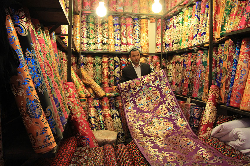
Su
Bazar es probablemente uno de los más antiguos y concurridos del mundo, un
lugar donde se puede encontrar alfombras de todo Oriente, camisas para vestir
el viernes en la mezquita, medias para ellas, etc.

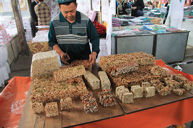


 |
| Postre hecho de arroz glutinoso, queso de cabra y miel. Absolutamente delicioso |
También
se venden serpientes secas, astas de animales, ungüentos y centenares de
remedios antiquísimos utilizados por la medicina tradicional uigur y china para
aliviar todo tipo de dolencias.
Todos
los domingos se celebra el "mercado dominical", un verdadero
espectáculo de imágenes y sonidos que hace retroceder al visitante hasta la
Edad Media.


Más de
50.000 personas se acercan desde las aldeas de la estepa y sus oasis para
comprar, vender o cambiar sus animales y frutas.
Una
ciudad anclada en una forma de vida muy antigua. Es, probablemente, el último
mercado medieval que todavía puede visitarse en este planeta.
Al
amanecer llegan los pastores al mercado con sus ovejas Bakhtiares o Karakul,
famosas por su capacidad para almacenar grandes cantidades de grasa en la cola
que les sirven de reserva en los inhóspitos parajes en los que ramonean.
Además
de abundante leche, estas famosas ovejas producen una lana áspera y larga, la
mejor para la fabricación de alfombras.
También
se ven ejemplares de ovejas del Himalaya y Cachemira, de cuya pequeña barba
-únicamente- se obtiene la preciada lana con la que se fabrican las carísimas y
exclusivas pashminas, tan codiciadas por las mujeres de todo el mundo.
Es
lógico que las pashminas auténticas (hay muchas de imitación) se coticen a
precios tan altos, ya que se necesitan muchas barbas de oveja cachemir (es
decir, muchas cabezas de ganado) para fabricar una sola pieza.
Tratantes
y pastores exponen el ganado y discuten con verdadero énfasis los precios de
compraventa. A veces, parece que van a llegar a las manos. Puro teatro; son
maestros en el arte del regateo.
Después
de acudir al mercado dominical, lo suyo es comer y descansar un rato. La comida
uigur es realmente exquisita y muy variada. Uno puede degustarla en cualquier
puesto de la calle y en algunos sencillos pero cómodos restaurantes, donde por
menos de tres euros el comensal puede disfrutar de un verdadero festín para el
paladar.
Kashgar
tiene dos partes bien definidas: la ciudad nueva y la Old City. La primera ha
sido erigida bajo los criterios de la arquitectura del régimen comunista, donde
la estética no existe.
Por el
contrario, la Old City, o ciudad antigua, fue levantada hace siglos por los
mercaderes uigures siguiendo pautas diametralmente opuestas. Sus casas se
construyeron primando la belleza y el preciosismo en sus fachadas, balcones y
galerías.
Contemplar
la hermosura de Kashgar era otro de los grandes alicientes de aquellas
caravanas que llegaban exhaustas a sus puertas.


El
gobierno de la República Popular China no demuestra ningún interés en conservar
y restaurar las casas de la Old City. Sus miradores de bellos mosaicos y madera
tallada y policromada se van derrumbando con el paso del tiempo y el olvido premeditado
de las autoridades.
Y en
el centro de esta Ciudad Antigua, la mezquita de Id Kah, una de las más grandes
del Lejano Oriente y visita obligada para todos los musulmanes de la región.
No
obstante, en Kashgar existen más de 60 mezquitas, todas ellas de pequeño tamaño
pero llenas de encanto, donde no ponen ningún reparo al visitante occidental
(siempre que se descalce al entrar y la mujer vaya respetuosamente vestida con
un pañuelo en la cabeza y las piernas y los brazos cubiertos).
Dentro
de la Old City se puede ver una colina, y sobre ella, un barrio lleno de
casas-taller, la mayoría con más de 500 años de antigüedad.
Koziqiyabixi,
que así se llama el lugar, es el barrio donde desde hace siglos los alfareros
fabrican vasijas de cerámica. De hecho, Koziqiyabixi significa en el idioma
uigur "la cerámica al borde del acantilado".
Las
calles son aquí un antiquísimo laberinto de piedra y adobe, y todas sus casas
distribuyen en diferentes pisos el horno de alfarero, la exposición y venta de
cerámica y el hogar familiar. En Koziqiyabixi toda la vida transcurre dentro de
las paredes del hogar; una casa que va pasando de padres a hijos, de generación
en generación desde hace 2.000 años.
Kashgar,
hermosa, atemporal. Recorriendo sus calles y mercados no es difícil imaginarse
las caravanas de camellos cargando telas, especias o perfumes para llevarlos al
otro extremo del mundo conocido.
Ante
el deterioro y abandono de tan bella ciudad, el viajero no puede comprender el
desdén de las autoridades chinas hacia estas tierras, sus moradores y sus
culturas. Incomprensible actitud que volveremos a encontrarnos en otros lugares
del país.
La
vieja Kashgar, la que fue la madre de todas las culturas, la joya que todos
quisieron poseer, donde no hubo ejército ni caravana que no se emocionara
acercándose a sus murallas.
Hoy,
destartalada y olvidada, agoniza bajo la aparente indiferencia de la China
Popular. Por aquí no ha pasado el milagro económico del gigante asiático. Quién
sabe, tal vez sea el turismo -si llega- el único capaz de impedir que la
hermosa Kashgar, sus gentes y su vieja y riquísima historia mueran en el
olvido.
Karakorum Hightway to Karakul Lake
Karakoram
highway trip is one of the best trip to do when you are in Kashgar.
The
Khunjirap pass is on the China Pakistan border between Tashkurgan Tajik
Autonomous County in China and Sost of Gilgit-Baltistan of Pakistan . It is the
highest paved international border crossing in the world and also the highest
point of the Karakorum Highway at an elevation of 4693 meters. It is 130 km to Tashkurgan, 420 km to Kashgar. The pass
is 42 km
from the National Park Station and checkpoint in Dil and 75 km from the customs and
immigration post in Sost. It is 270
km to Gilgit.


The
pass officially opened to Chinese and Pakistani citizens in 1985 and to third
country nationals in 1986.The pass used to remain open between 1st of May to
30th of November. According to new reports, the pass is now open from 1st of
April to 30th November. A separate
permit is required by people who want to visit the Khunjerab pass. This
permit can only be obtained from the military office in Tashkurgan. Since the
area is a military area, visiting Khunjerab pass is allowed only when the
situation in the area is stable.


Karakul
Lake (meaning "black lake") is located approximately 200km from
Kashgar.
At
an altitude of 3600m (though a height of nearer 3,900 m has been quoted), it is
the highest lake of the Pamir plateau, near the junction of the Pamir, Tian
Shan and Kunlun mountain ranges. Surrounded by mountains which remain
snow-covered throughout the year, the three highest peaks visible from the lake
are Muztagh Ata (7546m), Kongur Tagh (7649m) and Kongur Tiube (7530m). The lake
is popular among travelers for its unreal scenery and the clarity of its
reflection in the water, whose color ranges from a dark green to azure and
light blue. There are two Kirgiz settlements along the shore of Karakul lake, a
small number of yurts about 1km east of the bus drop-off point and a village
with stone houses located on the western shores.


Fall
can be quite cold and windy, and a same day return to Kashgar should be
considered if you're not well prepared. Summer is also quite cool, and a fleece
is recommended. Altitude sickness is a concern; people may experience headaches
after only a few hours at the lake. This may be another consideration for a day
trip.
Yarkand
Yarkand
es una ciudad-oasis situada en la provincia de Sinkiang en la República Popular
China. Según datos de 1990, su población era de 72.000 habitantes.
Yarkand
fue también el nombre de un antiguo reino budista situado entre Pishan y
Kasgar, en la rama de la Ruta de la Seda que transcurría por el extremo sur del
desierto de Taklamakán, en la cuenca del Tarim.


El
actual oasis está regado por las aguas del río Yarkand que fluye desde la
cordillera del Pamir (también llamadas ‘‘Congling’’, literalmente “montañas de
las cebollas” llamadas así por las abundantes cebollas salvajes que crecen en
la zona). El oasis ocupa un área total de 3.210 km² aunque fue mucho más
extenso antes del intenso periodo de sequía que afectó a la zona a partir del
siglo III.
La
ciudad está situada de forma estratégica a medio camino entre Jotán y Kasgar,
en la unión entre la rama norte hacía Aksu. Fue también estación de término
para las caravanas que llegaban desde la India vía Ladakh y que continuaban a
través del paso del Karakórum hasta la cuenca del Tarim.
Desde
Yarkand partía otra ruta destacada que se dirigía vía Tashkurghan al corredor
de Wakhan desde donde los viajeros podían atravesar de una forma relativamente
sencilla el paso de Baroghil situado en el actual norte de Pakistán o continuar
camino hacia el valle y hasta Badakshan.
Hotán
Es una ciudad-oasis situada en el
desierto de Taklamakán y que formó parte de la zona sur de la antigua Ruta de la Seda.
Jotán está situada al oeste del Río de
Jade Blanco, llamado así por el jade de este color que se encuentra en sus
depósitos aluviales. En la actualidad apenas queda jade pero el río sigue
siendo una de las principales fuentes de irrigación de la ciudad. Es también un
importante centro de producción de alfombras y productos derivados de la seda.


Jotán se hizo famosa al descubrirse
una serie de momias caucásicas que ponían de manifiesto que la zona había
estado habitada desde tiempos remotos por los tocarios*. La zona es rica en
yacimientos arqueológicos que se encuentran enterrados en las arenas del
desierto.
* Los tocarios fueron los hablantes de
un idioma indoeuropeo que habitaron más al este en la Antigüedad, poblando la
cuenca del Tarim en lo que hoy es la Región Autónoma Uigur de Sinkiang, en el oeste de
la actual República Popular China. Su peculiar cultura se extendió desde cerca
del 1800 a.
C. hasta finales del primer milenio de nuestra era. Su lengua se conoce como
tocario.
El
jade. The area has been famous for jade for centuries. Khotan jade is first
mentioned in written history about 200BC. There are mines, but much of the
stone is found in riverbeds. This is one of the few areas with black jade and
white jade. Be prepared to bargain hard.


Desierto del Taklamakan
Sin
lugar a dudas este era uno de los grandes hitos esperados del viaje. El
desierto del Taklamakan es un emblema en la Ruta de la Seda, caravanas a lo
largo de los siglos han intentado esquivarlo tanto por el sur como por el
norte, porque entrar en él significaba no salir debido a su dureza.
El
Desierto de Taklamakan ( o Takli makan ), es el desierto más grande de China,
así como el segundo desierto móvil más extenso del mundo. Con un área total de
330.000 km2, el desierto es tan vasto como el mar, extendiéndose más de 1.000
km de este a oeste y a lo largo de 400 km de norte a Sur.


El
ilimitado mar de arena en el desierto ha ganado la fama de ser un "mar de
la muerte", al cual "uno puede entrar pero del que nunca
saldrá". Sin embargo, en la lengua Uygur, "taklamakan" significa
"la vieja patria", porque en tiempos antiguos el lugar no era un
desierto, sino un bello oasis que había alimentado a numerosas y brillantes
civilizaciones.
Ubicado
en el centro de la Cuenca de Tarim en la región Autónoma de Xinjiang Uygur, el
Desierto de Taklamakan yace en el interior del continente euroasiático, rodeado
por tres lados por montañas de más de 4.000 metros sobre el nivel del mar: las
Montañas de Tianshan al norte, la Meseta de Qinghai-Tibet al sur y las Pamirs
al oeste. La lluvia es extraordinariamente rara en esta región, que solamente
tiene sol abrasador, noches heladas e incesantes ventarrones.
Sin
embargo, la región no es una zona prohibida para la vida. Las altas montañas
circundantes, al bloquear la entrada de aire húmedo también proporcionan agua
pura de la nieve derretida: los ríos Hotan, Keriya, Niya y Andir, todos
originados en las montañas nevadas y fluyendo a través del desierto. Algunos de
ellos se dispersan en el corazón del desierto, los ríos Hotan, Keriya, Niya y
Andirmientras otros nutren "corredores verdes", uno tras otro, en la
arena amarilla. Gracias a la existencia de los grandes ríos, la Ruta de la Seda
surgió del "mar de la muerte" y el desierto se convirtió en una
tierra próspera que presenció el intercambio entre varias importantes
civilizaciones.
La
Ruta de la Seda pasa por el Desierto de Taklamakan.
Según
los registros de la antigua historia de China solía haber 36 reinos en las
llamadas "Regiones de la Frontera Occidental", todos ellos
disfrutando de gran prosperidad y regados como perlas por el Desierto de
Taklimakan. Sin embargo debido a los cambios climáticos durante los últimos
varios miles de años, el desierto gradualmente ha mostrado su lado cruel,
tragándose un oasis tras otro sin misericordia y enterrando a todos aquellos
prósperos reinados bajo sus interminables dunas.
Comenzando
el siglo XIX, el Desierto de Taklamakan se ha convertirlo en un paraíso y una
casa de tesoros para los exploradores y arqueólogos de todo el mundo. Luan,
Niya y Mira, aquellas antiguas ciudades-Estado que solían existir solamente en
los libros de Historia han sido descubiertas y excavadas una tras otra. No
obstante, el ilimitado Desierto de Taklimakan conserva muchos secretos y quedan
sin resolver demasiados enigmas de la historia y de la civilización.
Aksu
Ciudad
en la que hice parada de una noche.
Kuqe
La
ciudad no tiene ningún interés turístico, pero en los alrededores hay dos
sitios muy interesantes que ver.
Kizil
Grottoes (Kizil thousand budha caves). One of
China's four grottoes which was built earlier than Mogao Grottoes of Dunhuang.
The 10,000 sq m of murals, kept in 236 caves are still in place today, are of
high value for artists and researchers alike. 55RMB entry, 25 for
students. Be advised you must go with a guide when visiting the grottoes who
will open the door to each individual cave for you from the outside. However
unless you pay 100RMB for an English guide you will have to do this with a
Chinese group for free. As all the guides are volunteers they're (rightly so)
very interested in their subject, which means you'll be subjected to very long
descriptions in Chinese about each grotto and frescos meanings, which can get a
bit tedious if you don't speak the language!
Tian Shan Grand Canyon Scenic Area a
surprisingly impressave mountain trail through some beautiful red mountains,
relative low on the annoying tourist groups and some fantastic photo
opportunities, especially on a clear day. 40RMB entry, half price for students.


A
driver to take you to both the Tian Shan Grand Canyon and Kizil Grottoes (and a
few other "sights" if you like...) can be arranged through the bus
station adjacent Jiao Tong Hotel (transportation hotel) 交通宾馆 front desk. It'll cost anywhere between 300 and 600
RMB depending on your bargaining skills / how Chinese you are (the guy started
at 600, we managed to get him to 450 being Western but speaking Chinese, and
then I was later told by an amused policeman that I shouldn't have paid more than
300).
Turpan
The
area around the city, the Turpan Depression
is the lowest point in China and second lowest on Earth (after the Dead Sea) at
154 meters
below sea level. It is very dry and sometimes very hot, well into the 40'sC.
No
place in China is hotter than Flaming Mountain in Turpan, a mountain made famous
by the classic Chinese mythological novel, Journey to the West.
Turpan
is famous for their grapes, grown primarily for raisins but also wine. Uyghurs
are the biggest ethnic group in the area (70%), followed by Han chinese.
Cerca de Turpan ha ymuchísimos
atractivos turísticos, unos fascinantes y otros que son una auténtica pérdida
de tiempo. La mejor forma de conocerlos es con un taxi. No hace falta
buscarlos, ellos te buscarán a ti. La compañía CTS organiza excursiones por
unos 60 CNY.
Emin
Minaret (额敏塔;
Émǐn Tǎ; also known as 苏公塔,
Sūgōng Tǎ). Es una de las
estructuras más bellas que se pueden ven en Xinjiang. Emin Minaret
was built in 1777 in honor of the heroic Turpan general, Emin Khoja; it's the
tallest minaret in China. It looks quite nice from the outside, but you can
neither climb up the big tower, nor go up to the second floor (due to
maintenance going on, Feb. 2015).
Astana ancient tombs. Astana tombs
countless Gaochang people sleeping on the strip the Gobi wilderness known as
the Underground Museum, more than 500 tombs have been excavated. A one of the
tombs, realistic or symbolic approach holds a lot of historical and cultural
relics from the Western Jin Southern and Northern Dynasties to the Tang
Dynasty, such as a large number of unearthed all kinds of instruments, pottery
wood silk, fully reflects the prosperity and the rise and fall of the
political, economic, cultural, illustrates the close ties of the Western
Regions and the Central Plains region. The Astana tombs to iron the fact that
Xinjiang since ancient times, the Chinese part of the family, whether ancient
or modern, belong to the Chinese nation the root of this source. These
all-encompassing, making fine heritage, embodied the then of Gaochang social
material and spiritual civilization, showing the true face of that period,
people said the Astana tombs of the the Gaochang history secret database.
entrance ticket:20.
Bezeklik
Thousand Buddha Caves (柏孜克里千佛洞; Bózīkèlǐ Qiānfódòng), (45km east of Turpan). Stand
high on the cliffs of west Mutou Valley under the Flaming Mountain.
Of the 83 original caves, 57 caves currently remain. The murals cover an area
over 1,200
square meters in more than 40 caves. Beginning in the
Southern and Northern Dynasties, the construction experienced Tang Dynasty, the
Five Dynasties, Song and Yuan dynasties. The Caves had been the Buddhist center
of Gaochang. Near the end of the 13 century, the royal family of Gaochang moved
to Yongchang, Gansu. Around this same time, Buddhism in
Turpan began to decline in popularity with the introduction of Islam.
Subsequently, the religious importance of The Bizalkik Thousand Buddha Caves
became less apparent. Many of the caves were destroyed during the ensuing
religious clashes. Vandals dug out the eyes of many of the portraits human
figures contained in the murals. Later, at the beginning of the 20 century,
foreign explorers robbed the caves of much of the treasures. Despite all the
destruction, the surviving parts, such as the delicate Buddha seat and the
bright color of the murals, give us some idea of its past glory.


Turpan
Grape Gully (吐鲁番葡萄沟; Tǔlǔfān
Pútaogōu), (10km from the city). Nicknamed Green Pearl City, an oasis of greenery,
made up of more than 200
hectares of grape. The best grapes in China have been
grown here for more than 1,000 years. The area you can actually see is painfully
small, full of tourists taking pictures of nothing in-particular (often you if
you're a western traveller), definitely not worth the 60RMB entrance ticket. 60
Y (30 for students but they'll try every excuse under the sun to avoid selling
the half-price tickets to a non-Chinese student).


Tuyoq
Village. about an hours drive outside Turpan city. Tuyoq is
an ancient Muslim pilgrimage sight and well preserved ancient town. Some local
followers claim 7 trips to Tuyoq is worth one trip to Mecca. It's not on the typical turpan
"tourist trail" so you won't be overrun with red-hats, flags and
loudspeakers. *tuyuk. a village with old houses about hundreds years ago. and
its canyon is full with ancient buddha caves.. and this place is known as the
chinese mecca This ancient village is situated 70km east of turpan city in a
lush gully carved. of the flaming mountain. vineyards surround this site and it
is famous for its oval-shaped seedless grapes. the raisins of this town is well
known in china. Tuyuq valley is unique and special spot for the religious and
traditional Uyghur lifestyle, This place is full of old buildings and houses
are connected with out directions. you are getting into amazing without any
scene of where you are, over a thousand years nothing seem changed here, last
time ,we met an very old woman who told us her grandfather even did not know
when the houses were built. This small village is full of the traditional
atmosphere of local uygur ,everything have kept intact .their lifestyle ,their
dress ,their behaviors in religion and the way in communication are all in
their own ways and still look the same as the old time,. although there are no
lodging here, you’ll assuredly be welcomed to spend the night in an Uyghur
family. they are very friendly. Tuyok valley is a mirror village here in
turpan. But in history it was a well known state, center of culture and
religion . recorded by quite a few important dynasties and races like tang
dynasty , gaochang state , jushi kingdom , etc. Today you see the most Muslim
monasteries visited by local Muslims. before here it was quite a place for
Buddhists who were converted later Muslims . So thing belong to Buddhists were
mostly destroyed during some thousands of years. Those murals and caves,
sculptures were somehow like those in china where Muslims did not have a chance
to do anything. dunhuang is not for away from here , still you have thousands
of caves containing millions of Buddhist arts 30.
Jiaohe
Ancient City (交河故城; Jiāohé Gùchéng), (about 20km west of Turpan - take
bus 102 or 101 heading west along Lao Cheng Lu from the bus station until it
terminates (Jiahe Lu kou 交河路口), then walk/hitch (hitchhiking works like this: When
you see a trike coming up your way, you either wave at them, or put up your
thumb. The driver stops and you jump up. The driver will go on his way and you
just tell him when you want to get off. You can try to give them some money,
though most of the people will decline your offer.) the last 5KM). Ruins of an
ancient Silk Road town. This city was
established during the Western Han Dynasty and continued through from the
period of Northern Wei Dynasty. 70 Rmb as of February 2015.


Turpan
Gaochang Ancient City (吐鲁番高昌故城; Tǔlǔfān
Gāochāng Gùchéng), (46km southeast of the city, you can get there either by
taxi or first by bus to Doushan or Sanbao
Township and then by
motorbike). 8AM-5PM. Ruins of an ancient Silk Road town standing isolated in
the Gobi Desert. Built in the 1st century B.C.
and originally called Gaochangbi, it used to be a garrison town. ¥20.
Kariz
wells, turpan china. an underground channel for water for
domestic use.clean and pure .a masterpiese built by local people 2000 years
ago. The karez, an irragation system with a history of 2000 years, is
considered as one of the three great ancient projects in china ,other two being
the great wall and grand canal. being placed side by side with the dujiangyan
irrigation project in sichuan province and the ling canal in guangxi , it is
also known as one of the three ancient water conservancy projects in china. the
karez is distributed in turpan, kumuk ,sanji , hotan ,atush ,kuqa and urumqi in history, but
mainly in turpan and kumul. the karez is a very delicate irrigation system
composed of vertical wells , underground canal , open canal and amall ponds or
reservoirs , with the main body buried under the ground. the system can be
devided into the water accumulation part and the water conveyance part. generally
the underground canals are at a height of 1.5--1.7m and a width of 0.6--0.7m ,
with total length of 5-20 km.
the number of the karez in xinjiang once reached 1784 . with 172367 vertical
wells , 5272 km
long underground canals and 858 million cubic meter of annual water output.
today there are only 614 karez left with and an annual output of 301 million
cubic meter.. of which there are 404 located in turpan are and yearly output is
230 million cubic meter of water, which remains the main water sources for
irrigation , drinking and ecological uses in some villages , 40.
Flaming
mountain. The flaming mountain is lying in the middle of the
turpan depression ,running from east to west, it is not only one of the well
know mountains in every Chinese families but also the branch ranges of the
tianshan mountains, the flaming mountain is 98km long and 9km wide and the
highest peak is 851m high above the sea level and the average altitude is 510m
above the sea level. The flaming mountains are entirely a bared and colorless
mountain except the reddish colored the soil and rocks, The mountain influence
the climate of the turpan depression. And at the same time it act like gaint
natural dam of the underground of the basin. Actually the flaming mountain was
formed in the oregenic movements of himalays ,in millions of years, the natural
weathering and numerous folded belts caused by crustal movement have formed the
undulating lies, crisscross gullies and ravines of the flaming mountain. under
the blazing sun the red rocks glows and hot air curls up like smoke as though
they were on fire, at the foot of the flaming mountain the ground temperature
reaches at about to 80 decrees, so it is said that eggs could be cooked under
the sand and fried on a rock, In recent years ,the numbers of visitors to the
mountains has been on the increase and a clamoring to go on the flaming
mountains tours has arisen.
Dunhuang
Esta es una parada obligatoria en una
ruta por China occidental. Es de hecho de las ciudades mas turísticas de esta
parte de China.
Cuevas de Mogao. Están consideradas el mejor ejemplo
de arte buddista chino.
En 1907, el británico Aurel Stein
descubrió en las cuevas budistas de Mogao un tesoro formado por miles de
manuscritos y pinturas.
A finales del siglo XIX, numerosos
exploradores europeos se adentraron en Asia Central siguiendo el rastro de la
antigua Ruta de la Seda. Hombres como el sueco Sven Hedin exploraron los
desiertos de Gobi y Taklamakán y hallaron restos de antiguas ciudades,
estatuillas, monedas y manuscritos escritos en lenguas diversas, como el
sánscrito, el chino o el tibetano.


Uno de estos exploradores fue Aurel
Stein, un erudito británico de origen húngaro que en 1888, cuando tenía 26
años, se instaló en Lahore (actual Pakistán) para estudiar la literatura
sánscrita. Entre 1899 y 1915, Stein realizó tres expediciones por China
occidental siguiendo el rastro de la antigua ruta caravanera. Fue a la vuelta
del primero de estos viajes cuando oyó hablar de unas cuevas budistas de gran
belleza y que ocultaban en su interior un increíble tesoro en manuscritos
antiguos. El lugar se llamaba Mogao o Mogaoku, «cuevas incomparables», aunque
popularmente era conocido como las cuevas de los Mil Budas. El explorador
decidió que se dirigiría allí en su nuevo viaje.
Mogao, en la actual provincia china de
Sinkiang, está situado a 19 kilómetros de Dunhuang, un antiguo oasis de la Ruta
de la Seda. En el año 366, un monje budista llamado Yuezun tuvo allí una visión
mística de mil budas de oro que brillaban sobre un desfiladero y a continuación
excavó una pequeña celda de meditación. Siguiendo su ejemplo, hasta el siglo
XIV muchos otros monjes fueron excavando grutas a lo largo de aquel risco, de
kilómetro y medio de longitud y unos 30 metros de altura. En total, se
horadaron casi 800 cuevas, que fueron adornándose con numerosas esculturas y
espléndidas pinturas murales.
Sand Dunes/Mingshashan - Yueyaquan
National Park (沙丘) - Crescent Lake. Este lago es un pequeño oasis en
mitad del desierto, y las dunas que hay a su alrededor un auténtico atractivo
turístico.


